

Garmin Navionics Vision+™ NVEU649L Norway - 010-C1276-00
Garmin Navionics Vision+™ NVEU649L Norway - 010-C1276-00 is backordered and will ship as soon as it is back in stock.
Estimated Shipping Widget will be displayed here! (with custom color)
Authorized dealer
Authorized dealer
Your #1 trusted source for Garmin products.
Shipping info
Shipping info
Most orders are processed and shipped from our USA warehouse within 1 to 3 business days of an order being placed (excluding weekends and holidays).
If, in the case, the item has a different handling and/or shipping estimate, it will be clearly displayed under the Add to cart button.
Returns info
Returns info
Eligible for returns: Yes
Time frame allotted: 30 days from the date of delivery
*Item(s) must be in new and unused condition to be eligible
To learn how to request a return please visit our return & refund policy:

Need assistance? We're happy to help!
 Call us
Garmin Navionics Vision+™ NVEU649L Norway - 010-C1276-00
Description
Description
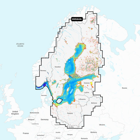
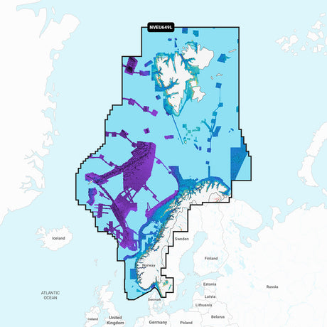
Navionics Vision+™ NVEU649L Norway
Get the world’s No. 1 choice in marine mapping with the best, most up-to-date Navionics®+ cartography on your compatible chartplotter.
Featuring vibrant colors, a streamlined interface, and combined coastal/inland content with a popular Navionics® style color palette, Garmin Navionics+ cartography makes it easy to plot your course. Multiple shading options aid in shallow-water navigation and make it easy to highlight a target depth range for the best fishing spots. Fully customizable with various chart layers, overlay combinations, and up to 10 color-shaded target depth ranges, users can scope out the best fishing spots.
When you purchase a new Garmin Navionics+ or Garmin Navionics Vision+ cartography product, a one-year subscription is included.
Chart Code - NVEU649L
Coverage Area:
Detailed coverage of the entire coast of Norway and parts of Sweden. Coverage includes the Oslofjord; the Sognefjord; the Vestfjorden; Jan Mayen Island; Svalbard; Lakes Mjøsa, Bandak, Kviteseidvatnet, Flåvatn, and Norsjø and the Telemark Canal in Norway; Lakes Vänern and Vättern; and the Trollhätte and Göta Canals in Sweden. Ports include Gothenburg in Sweden and Kristiansand, Stavanger, Bergen, Trondheim, Tromsø, and Narvik in Norway.
Features:
- All-in-one Map Solution - Access detail-rich mapping of coastal features, lakes, rivers, and more. Integrated Garmin and Navionics® content offers coverage for boaters worldwide.
- Daily Chart Updates - Charts are constantly being enhanced with new and amended content — as many as 5,000 updates are made daily. The one-year included subscription gives you access to daily chart updates via the ActiveCaptain app.
- Auto Guidance+ Technology - Combining the best of Garmin and Navionics automatic routing features, built-in Auto Guidance+ technology1 gives you a suggested dock-to-dock path to follow through channels, inlets, marina entrances, and more.
- Depth Range Shading - High-resolution depth range shading lets you select up to 10 color-shaded options and view your designated target depths at a glance.
- Up to 1' Contours - For improved fishing and navigation, up to 1' contours provide a clear depiction of bottom structure for improved fishing charts and enhanced detail in swamps, canals, harbors, marinas, and more.
- Shallow Water Shading - To give a clear picture of shallow waters to avoid, this feature allows for shading at a user-defined depth.
- ActiveCaptain Community - Community-sourced content provides useful POIs, such as marinas, anchorages, hazards, businesses, and more. Get recommendations from boaters with firsthand experience of the local environment.
- High-Resolution Relief Shading - This downloadable shading feature combines color and shadow to give you an easy-to-interpret, clearer view of the bottom structure than contour lines alone.
- High-Resolution Satellite Imagery - Downloadable high-resolution satellite imagery provides superior situational awareness.
- Aerial Photography - Crystal-clear aerial and surface photos of ports, marinas, bridges, docks, boat ramps, dams, and navigational landmarks provide a better sense of your surroundings above the waterline.
- 3D Fisheye View - This underwater perspective shows a 3D representation of the bottom and contours from below the waterline. Interface with sonar data for a customized view.
- 3D Marinereye View - This view provides a 3D representation of the surrounding area above and below the waterline.
- Dynamic Lake Level - Adjust your maps to the lake’s current water levels to see if spots are accessible or too shallow to explore.
Compatibility:
- Check the compatibility of Garmin Navionics+ content and features with your GPS chartplotter
Technical Specifications:
- Format - MicroSD/SD Card
In the Box:
- SD/MSD Card
1Auto Guidance+ is for planning purposes only and does not replace safe navigation operations
2Raster cartography cannot be viewed on echoMAP™ CHIRP and ECHOMAP™ Plus combos but can be viewed on mobile devices via the ActiveCaptain mobile app
*Sold as an Individual
Manufacturer : Garmin
Manufacturer Part No : 010-C1276-00
Videos
Video 1
Documentation

Payment & Security
Payment methods
Your payment information is processed securely. We do not store credit card details nor have access to your credit card information.
More from Garmin
View all-
 Free shippingSold out
 -
 Free shippingUp to $210.00 off
Garmin
Garmin GPSMAP® 943 Chartplotter GN+ Non-Sonar With U.S. and Canada Mapping Navionics+ - 010-02366-60
$1,399.99$1,609.99Unit price /UnavailableVery low stock (1 unit) -
Free shippingUp to $63.00 off
Garmin
Garmin Striker Vivid 7cv 7" Fishfinder GPS Track Plotter With GT20 - 010-02552-00
$419.99$482.99Unit price /UnavailableIn stock -
Free shippingUp to $450.00 off
Garmin
Garmin GPSMAP® 1223xsv Combo GPS/Fishfinder - Worldwide - 010-02367-02
$2,999.99$3,449.99Unit price /UnavailableLow stock (10 units) -
Free shippingSold out
Garmin
Garmin Force® Kraken Trolling Motor - 63" - Black with GT56UHD Transducer - 010-02573-00
$3,699.99$4,254.99Unit price /Unavailable -
Free shippingUp to $405.00 off
Garmin
Garmin GPSMAP® 8410xsv 10" Chartplotter/Sounder Combo with Worldwide Basemap - 010-02091-02
$2,699.99$3,104.99Unit price /UnavailableVery low stock (3 units) -
Free shippingUp to $533.00 off
Garmin
Garmin Force™ Freshwater Trolling Motor - 50" - 010-02024-00
$3,549.99$4,082.99Unit price /UnavailableVery low stock (2 units) -
Free shippingUp to $330.00 off
Garmin
Garmin GMR Fantom™ 18x Dome Radar - White - 010-02584-00
$2,199.99$2,529.99Unit price /UnavailableVery low stock (7 units) -
Free shippingUp to $78.00 off
Garmin
Garmin Striker Vivid 7sv 7"" Fishfinder Gps Track Plotter With Gt52 - 010-02553-00
$519.99$597.99Unit price /UnavailableLow stock (15 units) -
Free shippingUp to $450.00 off
Garmin
Garmin GPSMAP® 1243xsv Combo GPS/Fishfinder GN+ - 010-02367-61
$2,999.99$3,449.99Unit price /UnavailableIn stock -
Free shippingUp to $90.00 off
Garmin
$599.99$689.99Unit price /UnavailableVery low stock (7 units) -
Free shippingUp to $540.00 off
Garmin
Garmin GPSMAP® 8612 Chartplotter GN+ - 010-02092-50
$3,599.99$4,139.99Unit price /UnavailableLow stock (12 units) -
Free shippingSold out
Garmin
Garmin GPSMAP® 723xsv Combo GPS/Fishfinder w/GMR 18HD+ Radar - 010-02365-50
$1,593.99$2,599.99Unit price /Unavailable -
 Free shippingUp to $600.01 off
Garmin
Garmin Echomap Ultra 2 106sv Livescope Plus Bundle With Gt56uhd-tm Transducer - 010-02880-01LSP
$3,999.98$4,599.99Unit price /UnavailableLow stock (9 units) -
Free shippingUp to $540.01 off
Garmin
Garmin Echomap Ultra 2 106sv Livescope Plus Bundle No Transducer - 010-02880-00LSP
$3,599.98$4,139.99Unit price /UnavailableVery low stock (4 units) -
Free shippingUp to $660.01 off
Garmin
Garmin Echomap Ultra 2 126sv Livescope Plus Bundle No Transducer - 010-02882-00LSP
$4,399.98$5,059.99Unit price /UnavailableLow stock (14 units) -
Free shippingUp to $720.01 off
Garmin
Garmin ECHOMAP Ultra 2 126sv LIVESCOPE Plus Bundle with GT56UHD-TM Transducer - 010-02882-01LSP
$4,799.98$5,519.99Unit price /UnavailableIn stock -
Free shippingUp to $720.01 off
Garmin
Garmin Echomap Ultra 2 122sv Livescope Plus Bundle With Gt56uhd-tm Transducer - 010-02881-01LSP
$4,799.98$5,519.99Unit price /UnavailableVery low stock (3 units) -
Free shippingUp to $600.01 off
Garmin
$3,999.98$4,599.99Unit price /UnavailableVery low stock (4 units) -
Free shippingUp to $19.00 off
Garmin
Garmin GPS 19x HVS NMEA 0183 - 010-01010-00
$180.99$199.99Unit price /UnavailableVery low stock (2 units) -
Free shippingUp to $158.00 off
Garmin
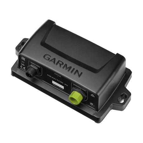
Garmin Course Computer Unit - Reactor™ 40 - 010-11052-67
$1,049.99$1,207.99Unit price /UnavailableVery low stock (3 units) -
Free shippingUp to $390.00 off
Garmin
Garmin Course Computer Unit - Reactor™ 40 Steer-by-wire - 010-11052-65
$2,599.99$2,989.99Unit price /UnavailableVery low stock (3 units) -
Free shippingSold out
Garmin
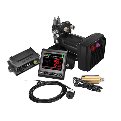
Garmin Reactor™ 40 Hydraulic Autopilot w/SmartPump v2 & GHC™ 20 Display - 010-00705-79
$2,779.99$4,199.99Unit price /Unavailable -
Free shippingUp to $9.00 off
Garmin
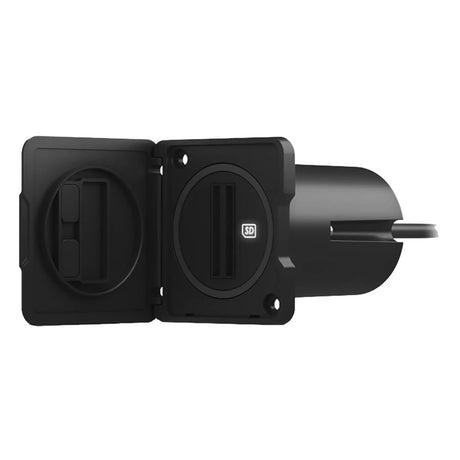
Garmin USB Card Reader w/USB-C Adapter Cable - 010-02251-10
$120.99$129.99Unit price /UnavailableLow stock (17 units)


More Marine - Cartography - Garmin Navionics Vision+ - Foreign
View all-
Free shippingUp to $26.00 off
Garmin
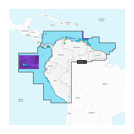
Garmin Navionics Vision+™ NSSA011R South America (North) - 010-C1452-00
$223.99$249.99Unit price /UnavailableIn stock -
Free shippingUp to $26.00 off
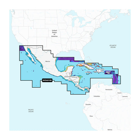
Garmin
Garmin Navionics Vision+™ NVSA010R Central America & Caribbean - 010-C1451-00
$223.99$249.99Unit price /UnavailableIn stock -
Free shippingUp to $26.00 off
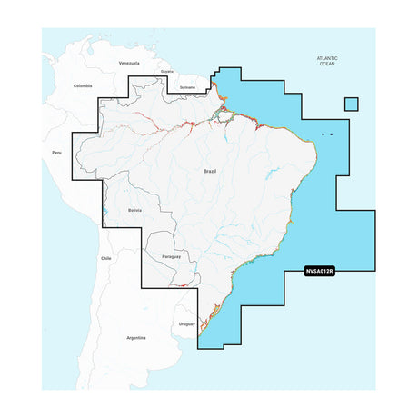
Garmin
Garmin Navionics Vision+™ NVSA012R Brazil - 010-C1453-00
$223.99$249.99Unit price /UnavailableIn stock -
Free shippingSold out
Garmin
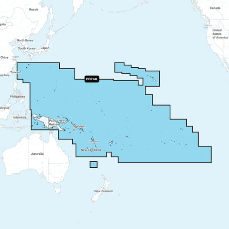
Garmin Navionics Vision+ NVPC014L Pacific Islands - 010-C1279-00
$307.99$349.99Unit price /Unavailable -
Free shippingUp to $47.00 off
Garmin
Garmin Navionics Vision+™ NVEU644L Baltic Sea - 010-C1273-00
$302.99$349.99Unit price /UnavailableVery low stock (6 units) -
Free shippingUp to $47.00 off
Garmin
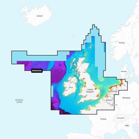
Garmin Navionics Vision+™ NVEU628L U.K., Ireland & Holland - 010-C1271-00
$302.99$349.99Unit price /UnavailableVery low stock (6 units) -
Free shippingUp to $47.00 off
Garmin
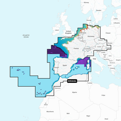
Garmin Navionics Vision+™ NVEU646L Europe, Central & West - 010-C1275-00
$302.99$349.99Unit price /UnavailableVery low stock (6 units) -
Free shippingUp to $47.00 off
Garmin
Garmin Navionics Vision+™ NVEU649L Norway - 010-C1276-00
$302.99$349.99Unit price /UnavailableVery low stock (6 units) -
Free shippingUp to $47.00 off
Garmin
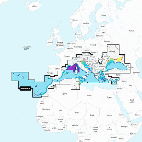
Garmin Navionics Vision+™ NVEU643L Mediterranean & Black Sea - 010-C1272-00
$302.99$349.99Unit price /UnavailableVery low stock (6 units) -
Free shippingUp to $47.00 off
Garmin
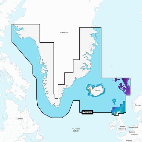
Garmin Navionics Vision+™ NVEU620L Greenland & Iceland - 010-C1270-00
$302.99$349.99Unit price /UnavailableVery low stock (6 units) -
Free shippingUp to $47.00 off
Garmin
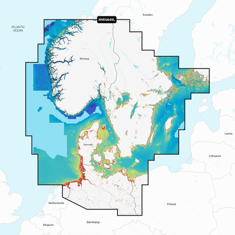
Garmin Navionics Vision+™ NVEU645L Skagerrak & Kattegat - 010-C1274-00
$302.99$349.99Unit price /UnavailableVery low stock (6 units) -
Free shippingUp to $19.00 off
Garmin
Garmin Navionics Vision+ NVAE018R - Yellow Sea- Marine Chart - 010-C1216-00
$180.99$199.99Unit price /UnavailableVery low stock (4 units) -
Free shippingSold out
Garmin
Garmin Navionics Vision+ NVEU050R - Gulf of Finland & Riga - Marine Chart - 010-C1249-00
$217.99$249.99Unit price /Unavailable -
Free shippingSold out
Garmin
$217.99$249.99Unit price /Unavailable -
Free shippingSold out
Garmin
Garmin NVEU010R Spain, Mediterranean Coast - Marine Charts Garmin Navionics Vision+ - 010-C1237-00
$217.99$249.99Unit price /Unavailable -
Free shippingSold out
Garmin
Garmin Navionics Vision+ NVEU077R - Denmark & Germany - Marine Chart - 010-C1243-00
$217.99$249.99Unit price /Unavailable -
Free shippingUp to $19.00 off
Garmin
Garmin Navionics Vision+ NVAE021R - Philippines - Marine Chart - 010-C1219-00
$180.99$199.99Unit price /UnavailableVery low stock (4 units) -
Free shippingSold out
Garmin
Garmin Navionics Vision+ NVEU055R - Finland, Lakes & Rivers - Inland Marine Chart - 010-C1254-00
$217.99$249.99Unit price /Unavailable -
Free shippingSold out
Garmin
Garmin Navionics Vision+ NVEU064R - Greenland - Marine Chart - 010-C1259-00
$217.99$249.99Unit price /Unavailable -
Free shippingSold out
Garmin
Garmin Navionics Vision+ NVEU078R - Oslo, Skagerrak & Haugesund - Marine Chart - 010-C1244-00
$217.99$249.99Unit price /Unavailable -
Free shippingUp to $19.00 off
Garmin
Garmin Navionics Vision+ NVAE016R - Japan - Lakes and Coast - Marine Chart - 010-C1215-00
$180.99$199.99Unit price /UnavailableVery low stock (4 units) -
Free shippingSold out
Garmin
Garmin Navionics Vision+ NVEU012R - Mediterranean Sea, Central & West - Marine Chart - 010-C1238-00
$217.99$249.99Unit price /Unavailable -
Free shippingSold out
Garmin
Garmin Navionics Vision+ NVEU003R - Great Britain, Northeast Coast - Marine Chart - 010-C1231-00
$217.99$249.99Unit price /Unavailable -
Free shippingSold out
Garmin
Garmin Navionics Vision+ NVAW015R - Indian Subcontinent - Marine Chart - 010-C1230-00
$217.99$249.99Unit price /Unavailable


Let customers speak for us

Quick response, will need more products in the near future

I like the simple design. Works well

does the job well

Extremely simple to install and assemble.

Works much better than expected. Bit tricky to maneuver, but does a great job overall.

This is definitely big and heavy but gets the job done. Finally got one, and it paid off after just a few stumps.

looks awesome with lifelike flames, runs all day, every day, and adds style without gobbling up electricity.

It's light, steady, and a blast to use.

Thinking about grabbing a couple more and maybe a solar charging setup.
Works better than expected, and assembly was simple.

Very satisfied with the boat 😊

chipper was easy to assemble and sturdy. exactly what i needed for clearing trees. just wish i had more time to use it!

Met expectations, very satisfied with performance.

Works as expected 🙂
Absolutely fantastic! Turned a mountain of branches into mulch in no time.
