

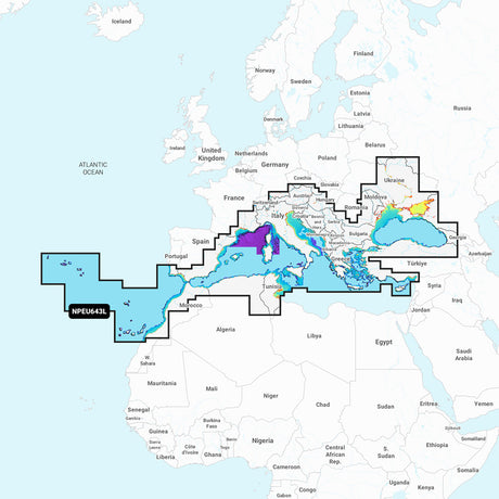
Navionics NPEU643L - Mediterranean & Black Sea - Navionics Platinum+ - 010-C1351-40
Navionics NPEU643L - Mediterranean & Black Sea - Navionics Platinum+ - 010-C1351-40 is backordered and will ship as soon as it is back in stock.
Estimated Shipping Widget will be displayed here! (with custom color)
Authorized dealer
Authorized dealer
Your #1 trusted source for Navionics products.
Shipping info
Shipping info
Most orders are processed and shipped from our USA warehouse within 1 to 3 business days of an order being placed (excluding weekends and holidays).
If, in the case, the item has a different handling and/or shipping estimate, it will be clearly displayed under the Add to cart button.
Returns info
Returns info
Eligible for returns: Yes
Time frame allotted: 30 days from the date of delivery
*Item(s) must be in new and unused condition to be eligible
To learn how to request a return please visit our return & refund policy:

Need assistance? We're happy to help!
 Call us
Description
Description
NPEU643L - Mediterranean & Black Sea - Navionics Platinum+
Navionics Platinum+™ charts include all the content of Navionics®+ cartography, with integrated offshore and inland mapping, 42,000+ lakes, and additional viewing options for relief shading, satellite imagery, 3D perspective view, aerial photos, and more.
The Navionics Chart Installer software also ensures the freshest chart data every time out. Navionics dock-to-dock route guidance solutions give you a suggested path to follow through channels, inlets, marina entrances, and more. Multiple shading options aid in shallow water navigation and make it easy to highlight a target depth range for the best fishing spots.
Chart Code - NPEU643L
Coverage Area:
Detailed coverage of the Mediterranean and Black Seas. Coverage includes the Azores, Madeira, the Canary Islands, Gibraltar, the Balearic Islands, Corsica, Sardinia, Sicily, Malta, Crete, Cyprus, the Dardanelles, the Bosporos, the Sea of Azov, the Dneiper River to the Kyivs'ke Reservoir, the Danube River to Passau, Germany, Lake Balaton, Lake Garda, Lake Como, and Lake Maggiore. Ports include Cadiz and Barcelona, Spain; Monaco; Marseille and Toulon, France; Genoa, Naples, Taranto, and Venice, Italy; Istanbul, Turkey; Odesa, Ukraine; Tunis, Tunisia and Algiers, Algeria.
Charts & Updates:
- Nautical Chart – Comprehensive charts are derived from multiple official, government, and private sources, displayed in a familiar look and feel
- SonarChart HD Bathymetry – Innovative 1' (0.5 m) bathymetry charts are created by using Navionics proprietary systems that augment existing content with sonar data contributed by the boating community
- Community Edits – Get useful local knowledge from edits made by users of the Navionics Boating app on your compatible smart device.
- Daily Updates – Up to 5,000 daily updates to our charts give you the most accurate, most current Navionics data available.
Advanced Features:
- Dock-to-dock Route Guidance – Start your trip with a suggested path.
- SonarChart Live Mapping Feature – Watch new HD depth maps develop in real-time as your boat moves through the water.
- Advanced Map Options – Customize your view to focus on the details that matter most
- Plotter Sync – Transfer routes and markers, update chart layers, and more — between your compatible chartplotter and the Boating app.
Overlays:
- Relief Shading – Get an easy-to-interpret, clearer view of the bottom structure.
- Satellite Imagery – offers a top-down view of inland and coastal areas.
- Sonar Imagery – View bottom hardness clearly and in contrasting colors.
Platinum+ Additional Viewing Options:
- 3D View – Adjust the perspective of your chart view to highlight key features and enhance awareness
- Aerial Photos – Get a better sense of your surroundings.
Coverage Areas:
- Worldwide map coverage is available, with integrated content making it easier to select the navigation features and map regions you want. Choose from large coverage areas (Large) to more localized chart cuts (Regular).
Compatibility:
- Check the compatibility of Platinum+ content and features with your GPS chartplotter.
Technical Specifications:
- Format - SD/MSD Card
In the Box:
- SD/MSD Card
1 Subscription required.
2 Dock-to-dock Route Guidance is for planning purposes only and does not replace safe navigation operations.
3 Subscription not required for SonarChart Live mapping feature on some chartplotter models; requires latest chartplotter firmware release.
*Sold as an Individual
*Navionics+ and Platinum+ cards are not compatible with Garmin chartplotters.
This product may not be returned to the original point of purchase. Please contact the manufacturer directly with any issues or concerns.
Manufacturer : Navionics
Manufacturer Part No : 010-C1351-40
UPC : 821245993113
Videos
Video 1
Documentation

Payment & Security
Payment methods
Your payment information is processed securely. We do not store credit card details nor have access to your credit card information.
More from Navionics
View all-
 Free shippingUp to $30.00 off
Navionics
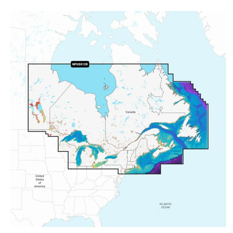
Navionics Platinum+ NPUS012R - Canada, East & Great Lakes - 010-C1466-40
$219.99$249.99Unit price /UnavailableVery low stock (4 units) -
Free shippingUp to $11.00 off
Navionics
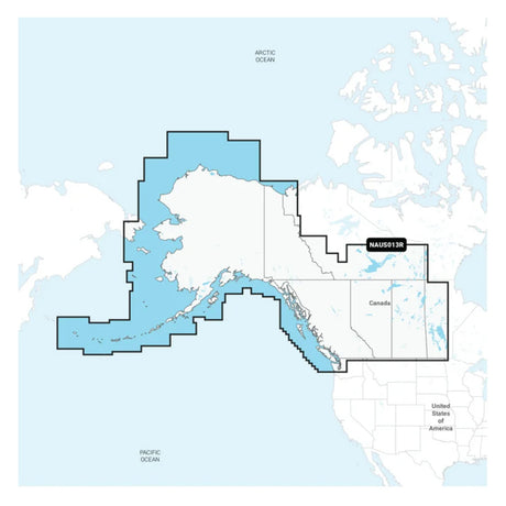
Navionics NAUS013R - Canada, West & Alaska - Navionics+ - 010-C1467-30
$138.99$149.99Unit price /UnavailableVery low stock (4 units) -
Free shippingUp to $11.00 off
Navionics
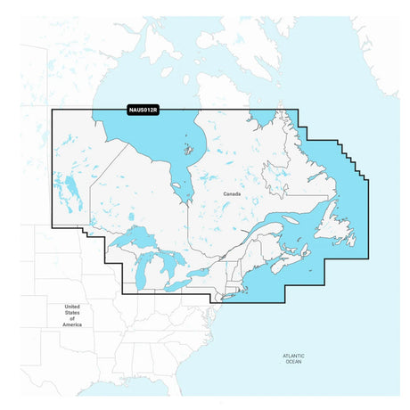
Navionics NAUS012R - Canada, East & Great Lakes - Navionics+ - 010-C1466-30
$138.99$149.99Unit price /UnavailableVery low stock (3 units) -
Free shippingUp to $25.00 off
Navionics
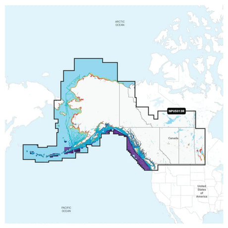
Navionics Platinum+ NPUS013R - Canada, West & Alaska - 010-C1467-40
$224.99$249.99Unit price /UnavailableVery low stock (2 units) -
Free shippingSold out
Navionics
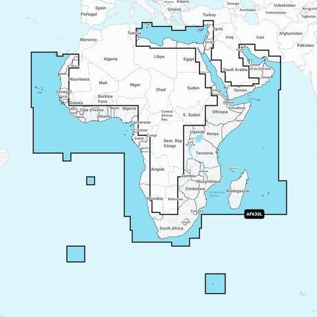
Navionics NAAF630L - Africa & Middle East - Navionics+ - 010-C1307-30
$220.99$249.99Unit price /Unavailable -
Free shippingSold out
Navionics
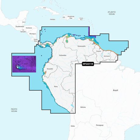
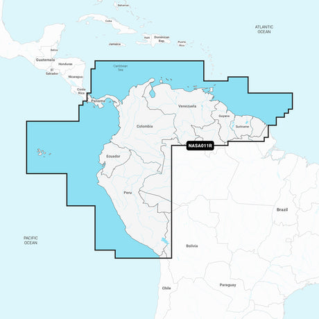
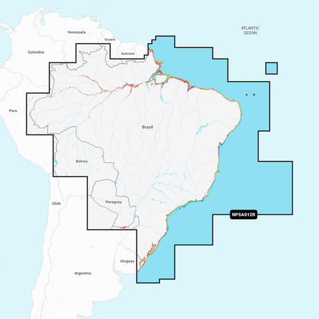
Navionics Platinum+ NPSA011R - South America North - 010-C1460-40
$223.99$249.99Unit price /Unavailable -
Free shippingSold out
Navionics
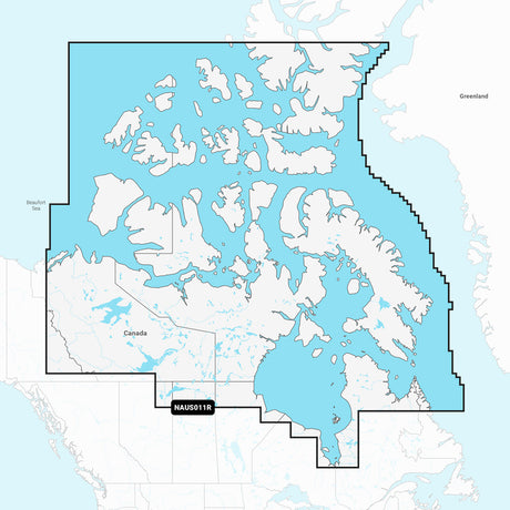
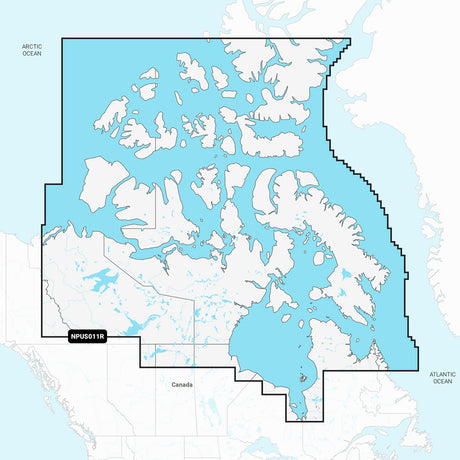
Navionics NAUS011R - Canada North - Navionics+ - 010-C1462-30
$138.99$149.99Unit price /Unavailable -
Free shippingSold out
Navionics
Navionics NAEU646L - Europe, Central & West - Navionics+ - 010-C1354-30
$220.99$249.99Unit price /Unavailable -
Free shippingSold out
Navionics
Navionics Platinum+ NPUS011R - Canada North - 010-C1462-40
$223.99$249.99Unit price /Unavailable -
Free shippingSold out
Navionics
Navionics NASA011R - South America North - Navionics+ - 010-C1460-30
$138.99$149.99Unit price /Unavailable -
Free shippingUp to $11.00 off
Navionics
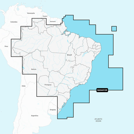
Navionics NASA012R - Brazil - Navionics+ - 010-C1461-30
$138.99$149.99Unit price /UnavailableVery low stock (1 unit) -
Free shippingSold out
Navionics
Navionics NPEU643L - Mediterranean & Black Sea - Navionics Platinum+ - 010-C1351-40
$324.99$349.99Unit price /Unavailable -
Free shippingSold out
Navionics
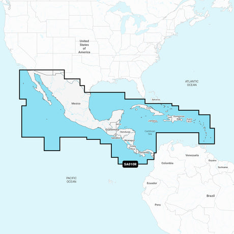
Navionics Platinum+ NPSA010R - Central America & Caribbean - 010-C1459-40
$223.99$249.99Unit price /Unavailable -
Free shippingSold out
Navionics
Navionics NASA010R - Central America & Caribbean - Navionics+ - 010-C1459-30
$138.99$149.99Unit price /Unavailable -
Free shippingSold out
Navionics
Navionics Platinum+ NPSA012R - Brazil - 010-C1461-40
$223.99$249.99Unit price /Unavailable -
Free shippingSold out
Navionics
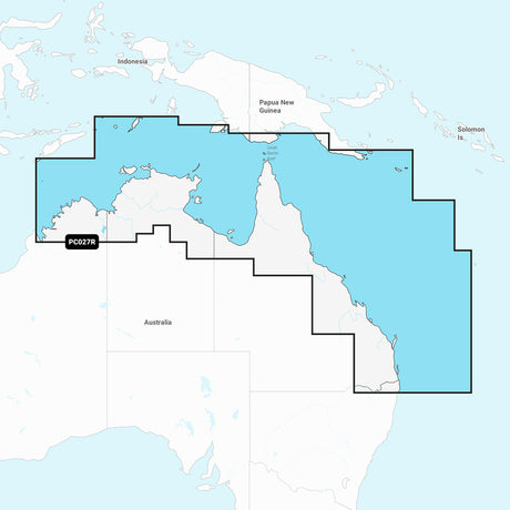
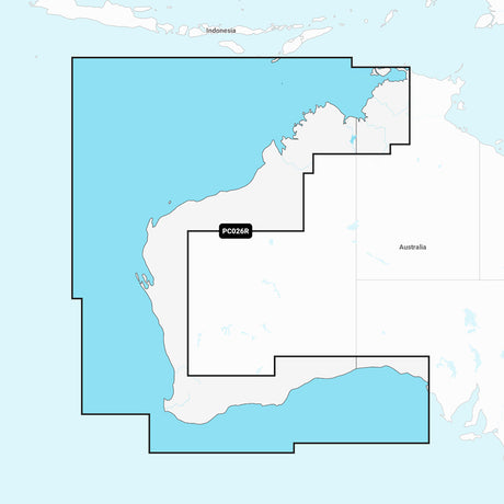
Navionics+ NAPC027R - Australia, Northeast - 010-C1360-30
$122.99$129.99Unit price /Unavailable -
Free shippingSold out
Navionics
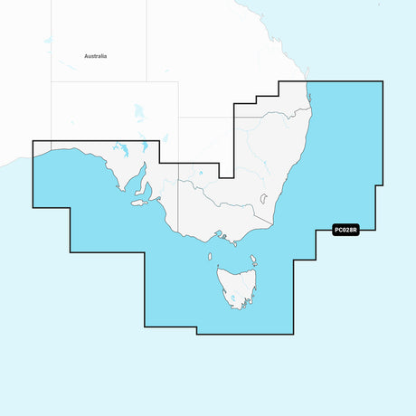
Navionics+ NAPC028R - Australia, Southeast - 010-C1361-30
$122.99$129.99Unit price /Unavailable -
Free shippingSold out
Navionics
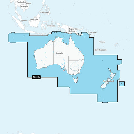
Navionics+ NAPC012L - Australia & New Zealand - 010-C1357-30
$217.99$239.99Unit price /Unavailable -
Free shippingSold out
-
Free shippingSold out
Navionics
Navionics+ NAPC026R - Australia, West - 010-C1359-30
$122.99$129.99Unit price /Unavailable -
Free shippingSold out
Navionics
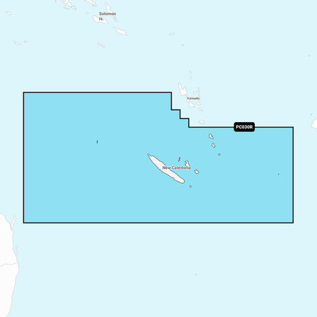
Navionics+ NAPC030R - New Caledonia - 010-C1363-30
$122.99$129.99Unit price /Unavailable -
Free shippingSold out
Navionics
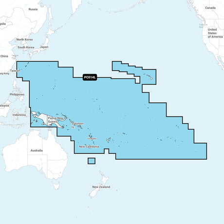
Navionics+ NAPC014L - Pacific Islands - 010-C1358-30
$212.99$239.99Unit price /Unavailable -
Free shippingSold out
Navionics
Navionics+ Preloaded Chart of All USA/Canada -Marine & Lakes- microSD™ - MSD/NAVPLUSNI
$175.99$199.00Unit price /Unavailable -
Free shippingSold out
Navionics
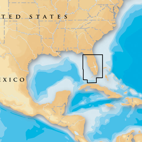
Navionics Platinum+ - South & Central Florida - microSD™/SD™ - MSD/632P+
$175.99$199.00Unit price /Unavailable


More Marine - Cartography - Navionics Platinum Plus Foreign
View all-
Free shippingSold out
Navionics
Navionics Platinum+ NPSA011R - South America North - 010-C1460-40
$223.99$249.99Unit price /Unavailable -
Free shippingSold out
Navionics
Navionics NPEU643L - Mediterranean & Black Sea - Navionics Platinum+ - 010-C1351-40
$324.99$349.99Unit price /Unavailable -
Free shippingSold out
Navionics
Navionics Platinum+ NPSA010R - Central America & Caribbean - 010-C1459-40
$223.99$249.99Unit price /Unavailable -
Free shippingSold out
Navionics
Navionics Platinum+ NPSA012R - Brazil - 010-C1461-40
$223.99$249.99Unit price /Unavailable
Let customers speak for us

Quick response, will need more products in the near future

I like the simple design. Works well

does the job well

Extremely simple to install and assemble.

Works much better than expected. Bit tricky to maneuver, but does a great job overall.

This is definitely big and heavy but gets the job done. Finally got one, and it paid off after just a few stumps.

looks awesome with lifelike flames, runs all day, every day, and adds style without gobbling up electricity.

It's light, steady, and a blast to use.

Thinking about grabbing a couple more and maybe a solar charging setup.
Works better than expected, and assembly was simple.

Very satisfied with the boat 😊

chipper was easy to assemble and sturdy. exactly what i needed for clearing trees. just wish i had more time to use it!

Met expectations, very satisfied with performance.

Works as expected 🙂
Absolutely fantastic! Turned a mountain of branches into mulch in no time.
