

Garmin GPSMAP® 1222 - Worldwide Basemap - 010-01741-00/LVS34
Garmin GPSMAP® 1222 - Worldwide Basemap - 010-01741-00/LVS34 is backordered and will ship as soon as it is back in stock.
Estimated Shipping Widget will be displayed here! (with custom color)
Authorized dealer
Authorized dealer
Your #1 trusted source for Garmin products.
Shipping info
Shipping info
Most orders are processed and shipped from our USA warehouse within 1 to 3 business days of an order being placed (excluding weekends and holidays).
If, in the case, the item has a different handling and/or shipping estimate, it will be clearly displayed under the Add to cart button.
Returns info
Returns info
Eligible for returns: Yes
Time frame allotted: 30 days from the date of delivery
*Item(s) must be in new and unused condition to be eligible
To learn how to request a return please visit our return & refund policy:

Need assistance? We're happy to help!
 Call us
Garmin GPSMAP® 1222 - Worldwide Basemap - 010-01741-00/LVS34
Description
Description
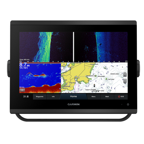
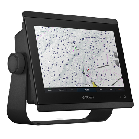
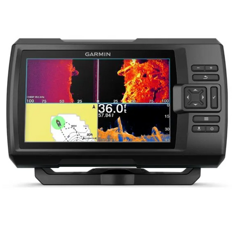
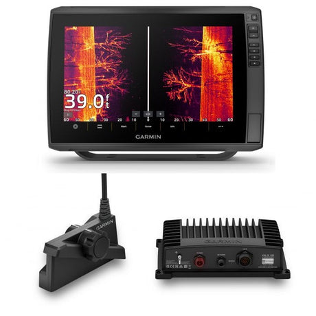
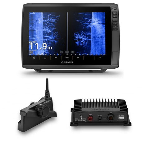
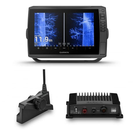
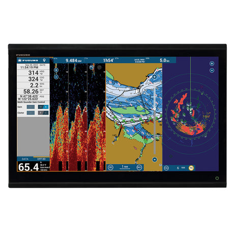
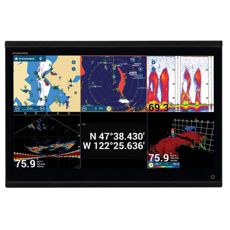
Garmin GPSMAP® 1222 12-inch Chartplotter LIVESCOPE Plus Bundle with Worldwide Basemap
Model: 010-01741-00/LVS34UPC: 753759168339
- 12-inch color display with keypad interface and multifunction control knob
- High-sensitivity internal 10 Hz GPS and GLONASS receiver
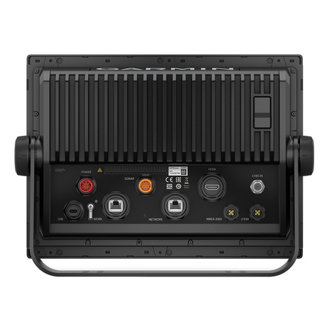
- Fully network capable for Garmin Marine Network and NMEA 2000® plus NMEA 0183 support
- Supports optional BlueChart® g2 Vision® HD charts for Auto Guidance and other premium navigation features
GPSMAP 1222 is designed for cruisers, sailors and sailing racers who need the advanced all-in-1 solution provided by our 10-inch keyed chartplotter. Features a large, bright screen coupled with a quick and easy-to-use keypad interface with user-programmable keys and a multifunction control knob.
Garmin Marine Network support allows sharing of sonar, maps, user data, dome or open-array radar, IP cameras and Panoptix™ sonar among multiple units. Includes NMEA 2000 network connectivity and NMEA 0183 support for autopilots, digital switching, weather, FUSION-Link, VHF, AIS and other sensors.
Enjoy built-in Wi-Fi connectivity for BlueChart Mobile 2.0 and Garmin Helm apps. Garmin Helm allows you to view and control your compatible chartplotter from a compatible smartphone or tablet while providing enhanced situational awareness for the mariner. With BlueChart Mobile, a free app downloaded from the App Store™, you can get reliable weather information while you plan marine routes on your iPad® or iPhone® then wirelessly transfer them to your boat’s compatible networked Garmin chartplotter. You can even stream and control a VIRB action camera from the chartplotter.
Enjoy built-in ANT wireless connectivity directly to quatix® marine watch, Garmin Nautix™ in-view display, gWind™ Wireless 2 transducer, GNX™ Wind marine instrument and wireless remote controls.
Fast, responsive built-in 10 Hz GPS and GLONASS receiver refreshes your position and heading 10 times each second to make your movement on the screen more fluid. It makes dropping up to 5,000 accurate waypoints — and finding your way back to them — quick and easy.
Two SD™ card slots provide expandable memory for accessory map purchases, such as LakeVü HD, LakeVü HD Ultra, BlueChart® g2 HD or BlueChart® g2 Vision® HD, which adds Garmin patented Auto Guidance and other great features.
To help you gain a wind-maximizing competitive edge, your chartplotter features a pre-race guidance page that shows your virtual starting line along with data fields showing laylines, time to burn before the start and a race timer that can be synchronized across all your networked Garmin GPS products. In addition, other supported sailing features include an enhanced wind rose, heading and course-over-ground lines, set and drift, true and apparent wind data and more.
If you have waypoints, tracks or frequently used routes stored on another manufacturer’s GPS product — or on a Garmin handheld device — it’s easy to transfer those items to your new Garmin chartplotter via industry-standard GPX software formatting.
1Auto Guidance is for planning purposes only and does not replace safe navigation operations.
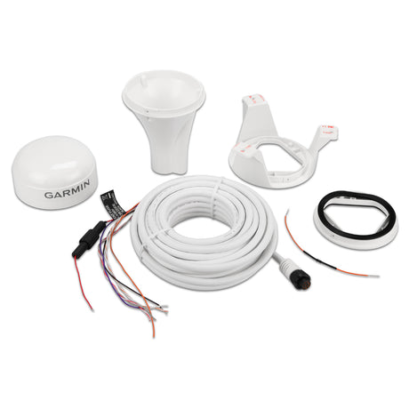
What's in the Box:
- GPSMAP 1222 chartplotter
- Power/data cable
- NMEA 2000 T-connector
- NMEA 2000 drop cable (2 m)
- Bail mount kit with knobs
- Flush mount kit with gasket
- Protective cover
- Trim piece snap covers
- Documentation
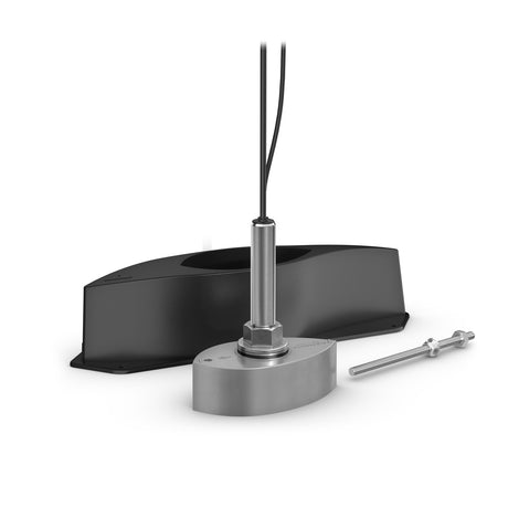
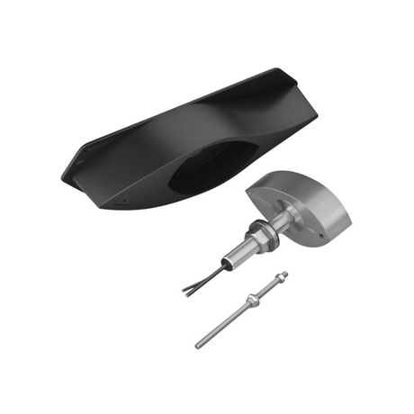
- LIVESCOPE Plus
Videos
Garmin Advanced All-in-One Combo Solutions
Documentation
Garmin GPSMAP® 1222 GPSMAP® 1222 - Worldwide Basemap

Specifications
Specifications
Garmin GPSMAP® 1222 GPSMAP® 1222 - Worldwide Basemap
| General | |
|---|---|
| DIMENSION | 14.1" x 8.9" x 2.7" (35.8 x 22.6 x 6.9 cm) |
| WEIGHT | 5.2 lbs (2.34 kg) |
| WATERPROOF | IPX7 |
| DISPLAY TYPE | WXGA, NP |
| DISPLAY SIZE | 10.3" x 6.4"; 12.1" diagonal (26.2 x 16.3 cm; 30.7 cm diagonal) |
| DISPLAY RESOLUTION | 1280 x 800 pixels |
| MOUNTING OPTIONS | Bail or flush |
| INPUT | Keyed |
| Maps & Memory | |
|---|---|
| ACCEPTS DATA CARDS | 2 SD™ cards |
| WAYPOINTS | 5000 |
| TRACK POINTS | 50000 |
| TRACKS | 50 saved tracks |
| NAVIGATION ROUTES | 100 |
| Sensors | |
|---|---|
| GPS | ✔ |
| GLONASS | ✔ |
| HAS BUILT-IN RECEIVER | ✔ |
| RECEIVER | 10 Hz |
| NMEA 2000 COMPATIBLE | ✔ |
| NMEA 0183 COMPATIBLE | ✔ |
| SUPPORTS WAAS | ✔ |
| Built-in Maps | |
|---|---|
| TIDE TABLES | ✔ |
| Optional Map Support | |
|---|---|
| BLUECHART G3 | ✔ |
| BLUECHART G3 VISION | ✔ |
| LAKEVÜ G3 | ✔ |
| LAKEVÜ G3 ULTRA | ✔ |
| GARMIN NAVIONICS+™ | ✔ |
| GARMIN NAVIONICS VISION+™ | ✔ |
| TOPO 100K | ✔ |
| STANDARD MAPPING | ✔ |
| GARMIN QUICKDRAW CONTOURS | ✔ |
| RASTER CHART SUPPORT | ✔ |
| Chartplotter Features | |
|---|---|
| SMART MODE COMPATIBLE | ✔ |
| AIS | ✔ |
| DSC | ✔ |
| SUPPORTS FUSION-LINK™ COMPATIBLE RADIOS | ✔ |
| GSD BLACK BOX SONAR SUPPORT | ✔ |
| GCV BLACK BOX SONAR SUPPORT | ✔ |
| ACTIVECAPTAIN® COMPATIBLE | yes |
| GRID (GARMIN REMOTE INPUT DEVICE) COMPATIBLE | ✔ |
| WIRELESS REMOTE COMPATIBLE | ✔ |
| SAILING FEATURES | ✔ |
| Electrical Features | |
|---|---|
| POWER INPUT | 10 to 32 Vdc |
| TYPICAL CURRENT DRAW AT 12 VDC | 2.2 A |
| MAXIMUM CURRENT DRAW AT 12 VDC | 2.9 A |
| MAXIMUM POWER USAGE AT 10 VDC | 34.8W |
| Sonar Features | |
|---|---|
| DISPLAYS SONAR | ✔ |
| TRADITIONAL SONAR (DUAL FREQUENCY/BEAM) | Yes (with external black box, sold separately) |
| CLEARVÜ | Yes (with external black box, sold separately) |
| SIDEVÜ | Yes (with external black box, sold separately) |
| PANOPTIX™ SONAR | ✔ |
| LIVESCOPE | ✔ |
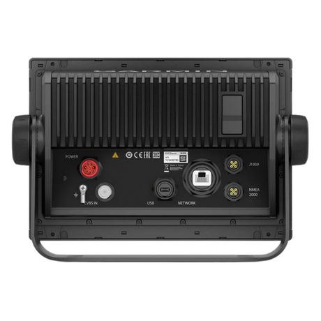
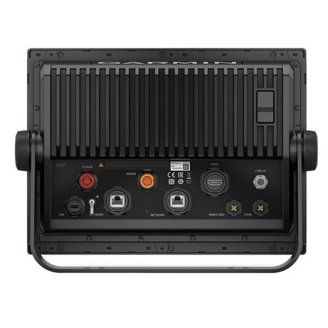
| Connections | |
|---|---|
| NMEA 2000® PORTS | 1 |
| CONNECTIONS NMEA0183 INPUT PORTS | 1 |
| NMEA 0183 OUTPUT (TX) PORTS | 1 |
| VIDEO INPUT PORTS | 1 (BNC composite) |
| GARMIN MARINE NETWORK PORTS | 2 |
| BLUETOOTH® PAIRING | ✔ |
| ANT+ (CONNECTIVITY) | ✔ |
| GARMIN WI-FI NETWORK (LOCAL CONNECTION) | ✔ |
Payment & Security
Payment methods
Your payment information is processed securely. We do not store credit card details nor have access to your credit card information.
More from Garmin
View all-
 Free shippingSold out
 -
 Free shippingUp to $210.00 off
Garmin
Garmin GPSMAP® 943 Chartplotter GN+ Non-Sonar With U.S. and Canada Mapping Navionics+ - 010-02366-60
$1,399.99$1,609.99Unit price /UnavailableVery low stock (6 units) -
Free shippingUp to $63.00 off
Garmin
Garmin Striker Vivid 7cv 7" Fishfinder GPS Track Plotter With GT20 - 010-02552-00
$419.99$482.99Unit price /UnavailableLow stock (16 units) -
Free shippingUp to $450.00 off
Garmin
Garmin GPSMAP® 1223xsv Combo GPS/Fishfinder - Worldwide - 010-02367-02
$2,999.99$3,449.99Unit price /UnavailableVery low stock (6 units) -
Free shippingSold out
Garmin
Garmin Force® Kraken Trolling Motor - 63" - Black with GT56UHD Transducer - 010-02573-00
$3,699.99$4,254.99Unit price /Unavailable -
Free shippingUp to $405.00 off
Garmin
Garmin GPSMAP® 8410xsv 10" Chartplotter/Sounder Combo with Worldwide Basemap - 010-02091-02
$2,699.99$3,104.99Unit price /UnavailableVery low stock (1 unit) -
Free shippingSold out
Garmin
Garmin Force™ Freshwater Trolling Motor - 50" - 010-02024-00
$3,549.99$4,082.99Unit price /Unavailable -
Free shippingUp to $330.00 off
Garmin
Garmin GMR Fantom™ 18x Dome Radar - White - 010-02584-00
$2,199.99$2,529.99Unit price /UnavailableLow stock (15 units) -
Free shippingUp to $78.00 off
Garmin
Garmin Striker Vivid 7sv 7"" Fishfinder Gps Track Plotter With Gt52 - 010-02553-00
$519.99$597.99Unit price /UnavailableLow stock (17 units) -
Free shippingUp to $450.00 off
Garmin
Garmin GPSMAP® 1243xsv Combo GPS/Fishfinder GN+ - 010-02367-61
$2,999.99$3,449.99Unit price /UnavailableIn stock -
Free shippingUp to $90.00 off
Garmin
$599.99$689.99Unit price /UnavailableVery low stock (2 units) -
Free shippingUp to $540.00 off
Garmin
Garmin GPSMAP® 8612 Chartplotter GN+ - 010-02092-50
$3,599.99$4,139.99Unit price /UnavailableLow stock (14 units) -
 Free shippingUp to $600.01 off
Garmin
Garmin Echomap Ultra 2 106sv Livescope Plus Bundle With Gt56uhd-tm Transducer - 010-02880-01LSP
$3,999.98$4,599.99Unit price /UnavailableVery low stock (2 units) -
Free shippingUp to $540.01 off
Garmin
Garmin Echomap Ultra 2 106sv Livescope Plus Bundle No Transducer - 010-02880-00LSP
$3,599.98$4,139.99Unit price /UnavailableVery low stock (2 units) -
Free shippingUp to $660.01 off
Garmin
Garmin Echomap Ultra 2 126sv Livescope Plus Bundle No Transducer - 010-02882-00LSP
$4,399.98$5,059.99Unit price /UnavailableVery low stock (2 units) -
Free shippingUp to $720.01 off
Garmin
Garmin ECHOMAP Ultra 2 126sv LIVESCOPE Plus Bundle with GT56UHD-TM Transducer - 010-02882-01LSP
$4,799.98$5,519.99Unit price /UnavailableVery low stock (2 units) -
Free shippingUp to $720.01 off
Garmin
Garmin Echomap Ultra 2 122sv Livescope Plus Bundle With Gt56uhd-tm Transducer - 010-02881-01LSP
$4,799.98$5,519.99Unit price /UnavailableVery low stock (2 units) -
Free shippingUp to $600.01 off
Garmin
$3,999.98$4,599.99Unit price /UnavailableVery low stock (2 units) -
Free shippingUp to $19.00 off
Garmin
Garmin GPS 19x HVS NMEA 0183 - 010-01010-00
$180.99$199.99Unit price /UnavailableVery low stock (2 units) -
Free shippingUp to $158.00 off
Garmin
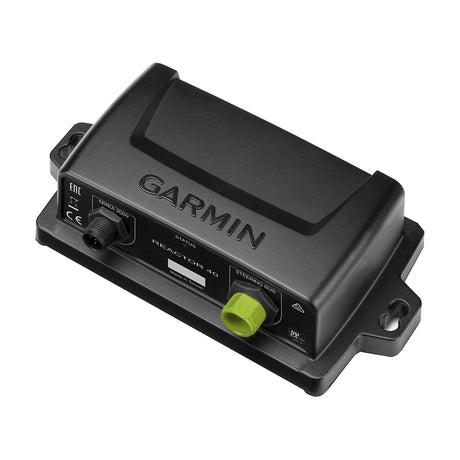
Garmin Course Computer Unit - Reactor™ 40 - 010-11052-67
$1,049.99$1,207.99Unit price /UnavailableVery low stock (2 units) -
Free shippingUp to $390.00 off
Garmin
Garmin Course Computer Unit - Reactor™ 40 Steer-by-wire - 010-11052-65
$2,599.99$2,989.99Unit price /UnavailableVery low stock (3 units) -
Free shippingSold out
Garmin
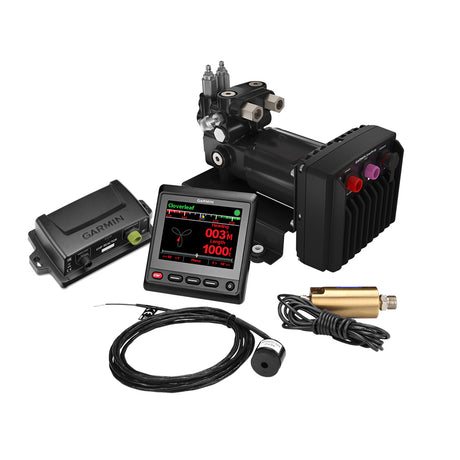
Garmin Reactor™ 40 Hydraulic Autopilot w/SmartPump v2 & GHC™ 20 Display - 010-00705-79
$4,099.99$4,199.99Unit price /Unavailable -
Free shippingUp to $8.00 off
Garmin
Garmin USB Card Reader w/USB-C Adapter Cable - 010-02251-10
$121.99$129.99Unit price /UnavailableVery low stock (6 units) -
 Free shippingUp to $750.00 off
Garmin
Garmin Panoptix™ PS70 Thru-Hull Transducer w/Fairing Block - 010-02768-00
$4,999.99$5,749.99Unit price /UnavailableVery low stock (2 units)


More Marine Navigation & Instruments - GPS - Chartplotters
View all-
Free shippingUp to $210.00 off
Garmin
Garmin GPSMAP® 943 Chartplotter GN+ Non-Sonar With U.S. and Canada Mapping Navionics+ - 010-02366-60
$1,399.99$1,609.99Unit price /UnavailableVery low stock (6 units) -
Free shippingUp to $540.00 off
Garmin
Garmin GPSMAP® 8612 Chartplotter GN+ - 010-02092-50
$3,599.99$4,139.99Unit price /UnavailableLow stock (14 units) -
Free shippingSold out
-
Free shippingSold out
-

 Free shippingSold out
 -
Free shippingSold out
Garmin
Garmin GPSMAP® 1643 Chartplotter GN+ - 010-02919-01
$4,799.99$5,519.99Unit price /Unavailable -
Free shippingUp to $450.01 off
Garmin
Garmin GPSMAP® 1022 - Worldwide Basemap - 010-01740-00/LVS34
$2,999.98$3,449.99Unit price /UnavailableVery low stock (2 units) -
Free shippingUp to $555.01 off
Garmin
Garmin GPSMAP® 1222 - Worldwide Basemap - 010-01741-00/LVS34
$3,699.98$4,254.99Unit price /UnavailableVery low stock (2 units) -
Free shippingUp to $420.00 off
Garmin
Garmin GPSMAP® 1223 Non-Sonar with Worldwide Basemap - 010-02367-00
$2,799.99$3,219.99Unit price /UnavailableVery low stock (4 units) -
Free shippingUp to $840.00 off
Garmin
Garmin GPSMAP® 8616 Chartplotter GN+ - 010-02093-50
$5,599.99$6,439.99Unit price /UnavailableVery low stock (5 units) -
Free shippingUp to $165.00 off
Garmin
Garmin GPSMAP723 7" Plotter with Worldwide Basemap - 010-02365-00
$1,099.99$1,264.99Unit price /UnavailableVery low stock (1 unit) -
Free shippingUp to $420.00 off
Garmin
Garmin GPSMAP® 1243 Chartplotter GN+ - 010-02367-60
$2,799.99$3,219.99Unit price /UnavailableVery low stock (5 units) -
Free shippingUp to $300.00 off
Garmin
Garmin GPSMAP® 1222 Keyed Networking Chartplotter - No Sonar - 010-01741-00
$1,999.99$2,299.99Unit price /UnavailableVery low stock (5 units) -
Free shippingUp to $390.00 off
Garmin
Garmin GPSMAP® 8410 10" Chartplotter with Worldwide Basemap - 010-02091-00
$2,599.99$2,989.99Unit price /UnavailableVery low stock (4 units) -
Free shippingSold out
-
Free shippingUp to $525.00 off
Garmin
Garmin GPSMAP® 8412 12" Chartplotter with Worldwide Basemap - 010-02092-00
$3,499.99$4,024.99Unit price /UnavailableVery low stock (3 units) -
Free shippingUp to $195.00 off
Garmin
Garmin GPSMAP® 1022 Keyed Networking Chartplotter - No Sonar - 010-01740-00
$1,299.99$1,494.99Unit price /UnavailableIn stock -
Free shippingSold out
Garmin
Garmin GPSMAP® 8416 16" Chartplotter w/Worldwide Basemap - 010-02093-00
$5,499.99$6,324.99Unit price /Unavailable -
Free shippingUp to $390.00 off
Garmin
Garmin GPSMAP® 8610 Chartplotter GN+ - 010-02091-50
$2,599.99$2,989.99Unit price /UnavailableVery low stock (7 units) -
Free shippingUp to $165.00 off
Garmin
Garmin GPSMAP743 7" Plotter US and Canada GN+ - 010-02365-60
$1,099.99$1,264.99Unit price /UnavailableVery low stock (4 units) -
Free shippingUp to $210.00 off
Garmin
Garmin GPSMAP923 9" Plotter - 010-02366-00
$1,399.99$1,609.99Unit price /UnavailableVery low stock (2 units) -
Free shippingUp to $2,070.00 off
Raymarine
Raymarine Axiom 2 XL 24 Multifunction Display - E70664
$13,799.99$15,869.99Unit price /UnavailableVery low stock (1 unit) -
Free shippingSold out
SI-TEX
SI-TEX 10" Chartplotter System w/Internal GPS & C-MAP 4D Card - ORIONC
$1,434.99$1,799.00Unit price /Unavailable -
Free shippingUp to $1,499.99 off
Simrad
Simrad NSO evo3S 24" MFD System Pack - 000-15128-001
$9,999.00$11,498.99Unit price /UnavailableVery low stock (1 unit)


Let customers speak for us

Quick response, will need more products in the near future

I like the simple design. Works well

does the job well

Extremely simple to install and assemble.

Works much better than expected. Bit tricky to maneuver, but does a great job overall.

This is definitely big and heavy but gets the job done. Finally got one, and it paid off after just a few stumps.

looks awesome with lifelike flames, runs all day, every day, and adds style without gobbling up electricity.

It's light, steady, and a blast to use.

Thinking about grabbing a couple more and maybe a solar charging setup.
Works better than expected, and assembly was simple.

Very satisfied with the boat 😊

chipper was easy to assemble and sturdy. exactly what i needed for clearing trees. just wish i had more time to use it!

Met expectations, very satisfied with performance.

Works as expected 🙂
Absolutely fantastic! Turned a mountain of branches into mulch in no time.
