


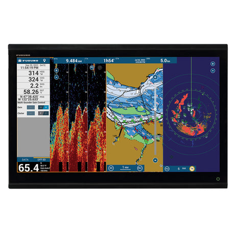
Garmin GPSMAP® 8616 Chartplotter GN+ - 010-02093-50
Garmin GPSMAP® 8616 Chartplotter GN+ - 010-02093-50 is backordered and will ship as soon as it is back in stock.
Estimated Shipping Widget will be displayed here! (with custom color)
Authorized dealer
Authorized dealer
Your #1 trusted source for Garmin products.
Shipping info
Shipping info
Most orders are processed and shipped from our USA warehouse within 1 to 3 business days of an order being placed (excluding weekends and holidays).
If, in the case, the item has a different handling and/or shipping estimate, it will be clearly displayed under the Add to cart button.
Returns info
Returns info
Eligible for returns: Yes
Time frame allotted: 30 days from the date of delivery
*Item(s) must be in new and unused condition to be eligible
To learn how to request a return please visit our return & refund policy:

Need assistance? We're happy to help!
 Call us
Garmin GPSMAP® 8616 Chartplotter GN+ - 010-02093-50
Description
Description
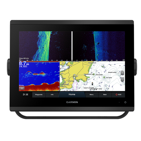
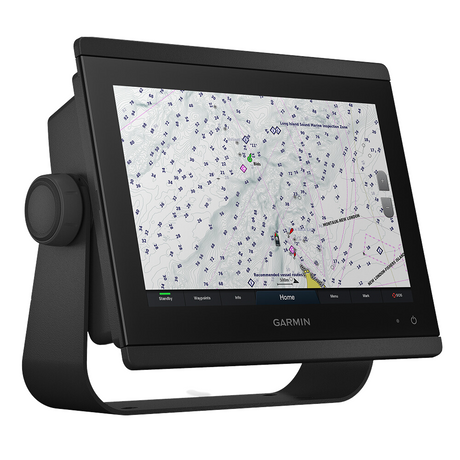
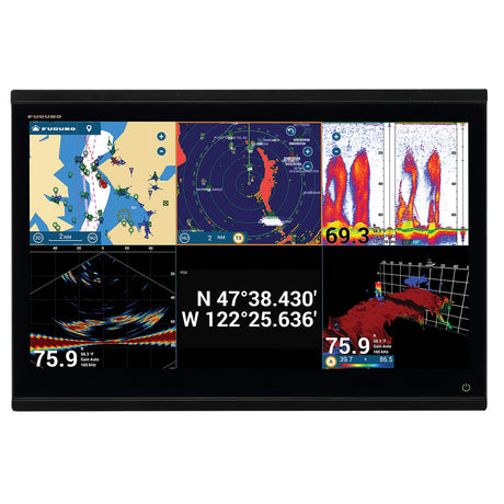
Garmin GPSMAP8616 16"" Plotter Garmin Navionics+ coastal and inland water charts for the U.S. and Canada
Model: 010-02093-50- Features a 16" full HD in-plane switching touchscreen display for wider viewing angles, superior clarity and sunlight readability, even with polarized sunglasses
- Adds a stunning appearance with ability to install multiple displays either flat mounted edge- to-edge to create a sleek glass helm look or mounted flush
- Fully network capable with NMEA 2000® connectivity and the Garmin Marine Network to easily build your marine system — from sonar, radar and autopilots to instruments, cameras and multimedia
- ANT® connectivity and Wi-Fi® networking let you connect with your compatible quatix® smartwatches, gWind™ Wireless 2 wind sensor and more
- For full control of your boat on your chartplotter screen, use our exclusive OneHelm™ feature to connect to many third-party devices
- See RPMs, fuel flow, temperature, trim and more for up to four of your compatible Mercury® engines by using the SmartCraft® Connect gateway
- Preloaded Garmin Navionics+™ coastal charts and inland mapping feature Auto Guidance+™ technology (Auto Guidance+ is for planning purposes only and does not replace safe navigation operations) ; plus, there’s support for optional Garmin Navionics Vision+™ premium map content.
- Compatible with the live sonar PS51 transducer with FrontVü™ forward-looking sonar, which helps you avoid running aground
- SmartMode™ station controls enable presets for one-touch access to docking, cruising, fishing, anchoring and more
- Built-in Garmin SailAssist™ features provide data, displays and prerace guidance needed to gain a competitive edge
- Use built-in Wi-Fi® networking to pair with the free ActiveCaptain® smartphone app for access to the OneChart™ feature, smart notifications, Garmin Quickdraw™ Community data and more.
- Dual microSD™ card slots on back of unit for use with the ActiveCaptain® app and cartography cards
The GPSMAP®8616 chartplotter features a 16" full HD in-plane switching touchscreen display for wider viewing angles, superior clarity and sunlight readability, even with polarized sunglasses. Experience superior connectivity and networking solutions with complete control of your entire system, right at your fingertips. The device is preloaded with Garmin Navionics+™coastal charts and inland mapping that feature Auto Guidance+™technology (Auto Guidance+ is for planning purposes only and does not replace safe navigation operations). Plus, there’s support for optional Garmin Navionics Vision+™premium map content. The chartplotter includes a premium-performance processor for our fastest map drawing, superior networking, video distribution and more. Multiple displays can be flat mounted edge-to-edge to create a sleek glass helm look or mounted flush. NMEA 2000®networking and the Garmin Marine Network allow you to build your full marine electronics suite — from radar and autopilots to cameras and instruments — controlled from your chartplotter and shared across multiple screens. With SmartMode™station controls, everything is designed to give you quick, one-touch access to the information you need to ease high-stress situations such as docking. For full control of your boat on your chartplotter screen, use our exclusive OneHelm™feature to connect to many compatible third-party devices. Built-in Garmin SailAssist™features provide data, displays and prerace guidance needed to gain a competitive edge. Download the ActiveCaptain® smartphone app to your smartphone or tablet to manage your marine experience from anywhere — from trip planning and prefishing to purchasing, downloading and updating maps. See RPMs, fuel flow, temperature, trim and more for up to four of your compatible Mercury®engines by using the SmartCraft®Connect gateway.
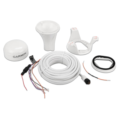
What's in the Box:
- GPSMAP 8616 Garmin Navionics+ coastal and inland water charts for the U.S. and Canada
- Power cable
- NMEA 2000® drop cable
- NMEA 2000 T-connector
- Documentation
- Flush mount kit
- Sun cover
- Trim piece snap covers
Videos
Garmin GPSMAP® 8600 Series: Total control now more compact
Documentation

Specifications
Specifications
Garmin GPSMAP8616 16" Plotter
| Specifications | |
|---|---|
| Physical Dimensions: | 15.1" X 10.3" X 3" (38.5 Cm X 26.3 Cm X 7.6 Cm) |
| Weight: | 9.6 Lbs (4.4 Kg) |
| Water Rating: | Ipx6 And Ipx7 |
| Display Type: | Touchscreen Ips Display (Anti-Glare Finish) |
| Display Size: | 13.6" X 7.7" (34.5 Cm X 19.5 Cm) |
| Display Resolution: | Fhd; 1920 X 1080 Pixels |
| Power Consumption: | 3.5 A |
| Antenna: | Internal Or External Over Nmea 2000 |
| Mounting Options: | Flat And Flush, Bail With Optional Accessory (Garmin Does Not Offer Any Hardware Or Accessories For A Flat-Mount Installation. Professional Tools And Knowledge Is Required.) |
| Receiver: | 10 Hz Gps/Glonass/Galileo |
| Garmin Marine Network™ Ports: | 2 |
| Maps & Memory | |
|---|---|
| Accepts Data Cards: | 2 Microsd Cards (On Back) |
| Waypoints: | 5000 |
| Routes: | 100 (250 Waypoints Each) |
| Track Log: | 50,000 Points; 50 Saved Tracks |
| Pre-Loaded Maps: | Garmin Navionics+ Coastal And Inland Water Charts For The U.S. And Canada |
| Chartplotter Features | |
|---|---|
| Garmin Radar Compatible: | Yes |
| Garmin Sonar Compatible: | Yes |
| Garmin Smartmode Compatible (Customizable Monitor Presets): | Yes |
| Supports Ais (Tracks Target Ships Position): | Yes |
| Supports Dsc (Displays Position Data From Dsc-Capable Vhf Radio): | Yes |
| Supports Fusion-Link™ Compatible Radios: | Yes |
| Gsd™ Black Box Sonar Support: | Yes |
| Gcv™ Black Box Sonar Support: | Yes |
| Activecaptain Compatible: | Yes |
| Garmin Helm Compatible: | Yes |
| Grid™ (Garmin Remote Input Device) Compatible: | Yes |
| Wireless Remote Compatible: | Yes |
| Sonar Features & Specifications | |
|---|---|
| Dual-Frequency (50/200 Khz) Sonar Capable: | Yes (With External Black Box, Sold Separately) |
| Dual-Beam (77/200 Khz) Sonar Capable: | Yes (With External Black Box, Sold Separately) |
| Frequencies Supported: | Na |
| Transmit Power: | Na |
| Chirp Sonar Technology: | Yes_(When_Connected_To_Another_Compatible_Sonar_Device) |
| Clearvü: | Yes (With Gcv™ Black Box, Sold Separately) |
| Sidevü: | Yes (With Gcv™ Black Box, Sold Separately) |
| Maximum Depth: | Na |
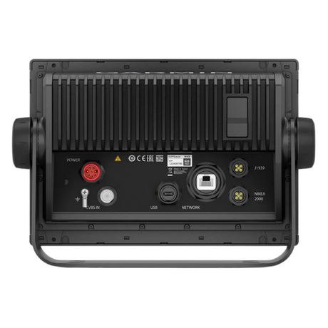
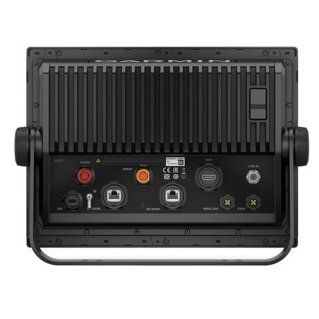
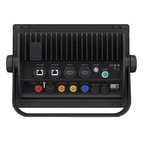
| Connections | |
|---|---|
| NMEA 2000® Compatible: | Yes |
| Transducer Pin Numbers: | NA |
| Nmea 0183 Input Ports: | 1 Differential |
| Nmea 0183 Output Ports: | 1 Differential |
| Video Input Ports: | 1 - Bnc Composite 1 - Hdmi (Hdcp Compliant) |
| Video Output Ports: | 1 Hdmi |
| Wireless Connectivity: | Yes |
Payment & Security
Payment methods
Your payment information is processed securely. We do not store credit card details nor have access to your credit card information.
More from Garmin
View all-
 Free shippingSold out
 -
 Free shippingUp to $210.00 off
Garmin
Garmin GPSMAP® 943 Chartplotter GN+ Non-Sonar With U.S. and Canada Mapping Navionics+ - 010-02366-60
$1,399.99$1,609.99Unit price /UnavailableVery low stock (6 units) -
Free shippingUp to $63.00 off
Garmin
Garmin Striker Vivid 7cv 7" Fishfinder GPS Track Plotter With GT20 - 010-02552-00
$419.99$482.99Unit price /UnavailableLow stock (16 units) -
Free shippingUp to $450.00 off
Garmin
Garmin GPSMAP® 1223xsv Combo GPS/Fishfinder - Worldwide - 010-02367-02
$2,999.99$3,449.99Unit price /UnavailableVery low stock (6 units) -
Free shippingSold out
Garmin
Garmin Force® Kraken Trolling Motor - 63" - Black with GT56UHD Transducer - 010-02573-00
$3,699.99$4,254.99Unit price /Unavailable -
Free shippingUp to $405.00 off
Garmin
Garmin GPSMAP® 8410xsv 10" Chartplotter/Sounder Combo with Worldwide Basemap - 010-02091-02
$2,699.99$3,104.99Unit price /UnavailableVery low stock (1 unit) -
Free shippingSold out
Garmin
Garmin Force™ Freshwater Trolling Motor - 50" - 010-02024-00
$3,549.99$4,082.99Unit price /Unavailable -
Free shippingUp to $330.00 off
Garmin
Garmin GMR Fantom™ 18x Dome Radar - White - 010-02584-00
$2,199.99$2,529.99Unit price /UnavailableLow stock (15 units) -
Free shippingUp to $78.00 off
Garmin
Garmin Striker Vivid 7sv 7"" Fishfinder Gps Track Plotter With Gt52 - 010-02553-00
$519.99$597.99Unit price /UnavailableLow stock (17 units) -
Free shippingUp to $450.00 off
Garmin
Garmin GPSMAP® 1243xsv Combo GPS/Fishfinder GN+ - 010-02367-61
$2,999.99$3,449.99Unit price /UnavailableIn stock -
Free shippingUp to $90.00 off
Garmin
$599.99$689.99Unit price /UnavailableVery low stock (2 units) -
Free shippingUp to $540.00 off
Garmin
Garmin GPSMAP® 8612 Chartplotter GN+ - 010-02092-50
$3,599.99$4,139.99Unit price /UnavailableLow stock (14 units) -
 Free shippingUp to $600.01 off
Garmin
Garmin Echomap Ultra 2 106sv Livescope Plus Bundle With Gt56uhd-tm Transducer - 010-02880-01LSP
$3,999.98$4,599.99Unit price /UnavailableVery low stock (2 units) -
Free shippingUp to $540.01 off
Garmin
Garmin Echomap Ultra 2 106sv Livescope Plus Bundle No Transducer - 010-02880-00LSP
$3,599.98$4,139.99Unit price /UnavailableVery low stock (2 units) -
Free shippingUp to $660.01 off
Garmin
Garmin Echomap Ultra 2 126sv Livescope Plus Bundle No Transducer - 010-02882-00LSP
$4,399.98$5,059.99Unit price /UnavailableVery low stock (2 units) -
Free shippingUp to $720.01 off
Garmin
Garmin ECHOMAP Ultra 2 126sv LIVESCOPE Plus Bundle with GT56UHD-TM Transducer - 010-02882-01LSP
$4,799.98$5,519.99Unit price /UnavailableVery low stock (2 units) -
Free shippingUp to $720.01 off
Garmin
Garmin Echomap Ultra 2 122sv Livescope Plus Bundle With Gt56uhd-tm Transducer - 010-02881-01LSP
$4,799.98$5,519.99Unit price /UnavailableVery low stock (2 units) -
Free shippingUp to $600.01 off
Garmin
$3,999.98$4,599.99Unit price /UnavailableVery low stock (2 units) -
Free shippingUp to $19.00 off
Garmin
Garmin GPS 19x HVS NMEA 0183 - 010-01010-00
$180.99$199.99Unit price /UnavailableVery low stock (2 units) -
Free shippingUp to $158.00 off
Garmin
Garmin Course Computer Unit - Reactor™ 40 - 010-11052-67
$1,049.99$1,207.99Unit price /UnavailableVery low stock (2 units) -
Free shippingUp to $390.00 off
Garmin
Garmin Course Computer Unit - Reactor™ 40 Steer-by-wire - 010-11052-65
$2,599.99$2,989.99Unit price /UnavailableVery low stock (3 units) -
Free shippingSold out
Garmin
Garmin Reactor™ 40 Hydraulic Autopilot w/SmartPump v2 & GHC™ 20 Display - 010-00705-79
$4,099.99$4,199.99Unit price /Unavailable -
Free shippingUp to $8.00 off
Garmin
Garmin USB Card Reader w/USB-C Adapter Cable - 010-02251-10
$121.99$129.99Unit price /UnavailableVery low stock (6 units) -
 Free shippingUp to $750.00 off
Garmin
Garmin Panoptix™ PS70 Thru-Hull Transducer w/Fairing Block - 010-02768-00
$4,999.99$5,749.99Unit price /UnavailableVery low stock (2 units)


More Marine Navigation & Instruments - GPS - Chartplotters
View all-
Free shippingUp to $210.00 off
Garmin
Garmin GPSMAP® 943 Chartplotter GN+ Non-Sonar With U.S. and Canada Mapping Navionics+ - 010-02366-60
$1,399.99$1,609.99Unit price /UnavailableVery low stock (6 units) -
Free shippingUp to $540.00 off
Garmin
Garmin GPSMAP® 8612 Chartplotter GN+ - 010-02092-50
$3,599.99$4,139.99Unit price /UnavailableLow stock (14 units) -
Free shippingSold out
-
Free shippingSold out
-

 Free shippingSold out
 -
Free shippingSold out
Garmin
Garmin GPSMAP® 1643 Chartplotter GN+ - 010-02919-01
$4,799.99$5,519.99Unit price /Unavailable -
Free shippingUp to $450.01 off
Garmin
Garmin GPSMAP® 1022 - Worldwide Basemap - 010-01740-00/LVS34
$2,999.98$3,449.99Unit price /UnavailableVery low stock (2 units) -
Free shippingUp to $555.01 off
Garmin
Garmin GPSMAP® 1222 - Worldwide Basemap - 010-01741-00/LVS34
$3,699.98$4,254.99Unit price /UnavailableVery low stock (2 units) -
Free shippingUp to $420.00 off
Garmin
Garmin GPSMAP® 1223 Non-Sonar with Worldwide Basemap - 010-02367-00
$2,799.99$3,219.99Unit price /UnavailableVery low stock (4 units) -
Free shippingUp to $840.00 off
Garmin
Garmin GPSMAP® 8616 Chartplotter GN+ - 010-02093-50
$5,599.99$6,439.99Unit price /UnavailableVery low stock (5 units) -
Free shippingUp to $165.00 off
Garmin
Garmin GPSMAP723 7" Plotter with Worldwide Basemap - 010-02365-00
$1,099.99$1,264.99Unit price /UnavailableVery low stock (1 unit) -
Free shippingUp to $420.00 off
Garmin
Garmin GPSMAP® 1243 Chartplotter GN+ - 010-02367-60
$2,799.99$3,219.99Unit price /UnavailableVery low stock (5 units) -
Free shippingUp to $300.00 off
Garmin
Garmin GPSMAP® 1222 Keyed Networking Chartplotter - No Sonar - 010-01741-00
$1,999.99$2,299.99Unit price /UnavailableVery low stock (5 units) -
Free shippingUp to $390.00 off
Garmin
Garmin GPSMAP® 8410 10" Chartplotter with Worldwide Basemap - 010-02091-00
$2,599.99$2,989.99Unit price /UnavailableVery low stock (4 units) -
Free shippingSold out
-
Free shippingUp to $525.00 off
Garmin
Garmin GPSMAP® 8412 12" Chartplotter with Worldwide Basemap - 010-02092-00
$3,499.99$4,024.99Unit price /UnavailableVery low stock (3 units) -
Free shippingUp to $195.00 off
Garmin
Garmin GPSMAP® 1022 Keyed Networking Chartplotter - No Sonar - 010-01740-00
$1,299.99$1,494.99Unit price /UnavailableIn stock -
Free shippingSold out
Garmin
Garmin GPSMAP® 8416 16" Chartplotter w/Worldwide Basemap - 010-02093-00
$5,499.99$6,324.99Unit price /Unavailable -
Free shippingUp to $390.00 off
Garmin
Garmin GPSMAP® 8610 Chartplotter GN+ - 010-02091-50
$2,599.99$2,989.99Unit price /UnavailableVery low stock (7 units) -
Free shippingUp to $165.00 off
Garmin
Garmin GPSMAP743 7" Plotter US and Canada GN+ - 010-02365-60
$1,099.99$1,264.99Unit price /UnavailableVery low stock (4 units) -
Free shippingUp to $210.00 off
Garmin
Garmin GPSMAP923 9" Plotter - 010-02366-00
$1,399.99$1,609.99Unit price /UnavailableVery low stock (2 units) -
Free shippingUp to $2,070.00 off
Raymarine
Raymarine Axiom 2 XL 24 Multifunction Display - E70664
$13,799.99$15,869.99Unit price /UnavailableVery low stock (1 unit) -
Free shippingSold out
SI-TEX
SI-TEX 10" Chartplotter System w/Internal GPS & C-MAP 4D Card - ORIONC
$1,434.99$1,799.00Unit price /Unavailable -
Free shippingUp to $1,499.99 off
Simrad
Simrad NSO evo3S 24" MFD System Pack - 000-15128-001
$9,999.00$11,498.99Unit price /UnavailableVery low stock (1 unit)


Let customers speak for us

Quick response, will need more products in the near future

I like the simple design. Works well

does the job well

Extremely simple to install and assemble.

Works much better than expected. Bit tricky to maneuver, but does a great job overall.

This is definitely big and heavy but gets the job done. Finally got one, and it paid off after just a few stumps.

looks awesome with lifelike flames, runs all day, every day, and adds style without gobbling up electricity.

It's light, steady, and a blast to use.

Thinking about grabbing a couple more and maybe a solar charging setup.
Works better than expected, and assembly was simple.

Very satisfied with the boat 😊

chipper was easy to assemble and sturdy. exactly what i needed for clearing trees. just wish i had more time to use it!

Met expectations, very satisfied with performance.

Works as expected 🙂
Absolutely fantastic! Turned a mountain of branches into mulch in no time.
